FOREWORD
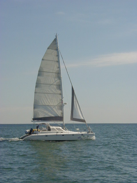
The Boat
Navigation and Data Collection
In the office on board, my laptop PC runs Nobeltec's Visual Navigation Suite electronic chart program, with a GPS data feed from the boat's systems. The screen display is repeated on a wall-mounted LCD screen in the main salon behind the lower steering station.
As well as providing the primary navigation resource, various data are recorded in the system every 15 minutes (such as lat/lon, boat speed) and I typically download these each evening along with narrative notes made during the day as the basis for the Ship's Log.
Boat Speed and Fuel Consumption
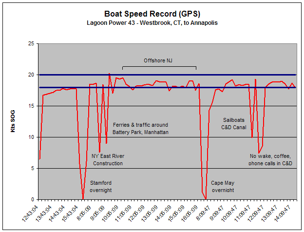
With a consistent and regular record of GPS boat speed, it's possible to reconstruct and graph the speed over ground during passages and these are presented at the bottom of each of the first seven legs.
:
THE PHOTO-JOURNAL
Click here to start at the beginning, or click on a particular leg below to go direct to that section.
Leg 1 - Westbrook, CT, to Annapolis, MD - 315nm
Leg 2 – Annapolis, MD, to Beaufort, NC - 371nm
Leg 3 - Beaufort, NC, to St Augustine, FL - 432nm
Leg 4 - St Augustine, FL, to Marathon, FL - 386nm
Leg 5 – Marathon to Sanibel Island, FL - 232nm
Leg 6 - Sanibel Island to Pensacola, FL - 462nm
Leg 7 - Pensacola to Florida Keys - 550nm
Leg 8 - In The Florida Keys then on to Miami, FL - 215nm
Leg 9 – Miami to Bahamas and back, Miami to Marathon and back - 333nm
Leg 10 – Miami to St Catherine's Sound, GA - 426nm
Leg 11 – Georgia to Annapolis, MD - 681nm
Leg 12 – Annapolis back to Westbrook, CT - 319nm
Leg One - Westbrook, CT, to Annapolis, MD - 315nm
Sunday, October 5, 2003
Departure from Westbrook, Connecticut, USA – Heading South
As usual, the planned time for throwing off lines came and went, with last minute gear and provisions to load, systems to be checked one more time, the latest VHF weather broadcast to be listened to…. The on-board office had already been set up, with all files and office supplies neatly stowed, laptop running, hooked to a color printer/scanner copier, and connected to the Internet via the satellite phone link. With Nobeltec Visual Navigation Suite's electronic charts running on the laptop, and displayed on the remote monitor in the main salon, this took care of route planning and navigation, and I could even download the latest weather forecast to overlay on the charts. A last stop at the fuel dock just after midday to top up the tanks, and then out into Long Island Sound, heading pretty much due west, into 15-20kts TWS (true wind speed) and short 2ft head-seas.
I expected the head-seas to give us a pretty good shakedown, but apart from the occasional slap on the bridge-deck the boat shrugged off both the conditions and our full load of fuel and supplies, running for a solid 4 hours at 17-18kts. Just after 4:00pm, turned into Yacht Haven Marina in Stamford to take a slip for the night, and to step ashore for dinner in the very pleasant company of my ex-wife.
* calculated by nm / engine hours, thus including all warm-up, cool down, "idling" time, anchoring, etc. Monday, October 6 – Stamford, CT, to Cape May, NJ Morning dew on deck, but bright sunshine promises a nice day on the water ahead.
With a light breeze from the
north, off the land, seas are flat and once out of Stamford Harbor we are making
a very comfortable 18-19kts towards the Manhattan skyline ahead. Not too much commercial traffic on the water this morning as we sweep down the East River past the unique architecture of Manhattan, catching the start of the ebb tide at Hell Gate that will flush us right out through New York Harbor, under the Verrazano Bridge and out past Sandy Hook into the coastal Atlantic waters off the New Jersey coastline. Off Sandy Hook, the breeze is light and on the starboard quarter, with long ocean swells running in from the southeast. The port bow rises only slightly as we mostly cut through rather than ride over the swell, still making our fast cruise speed of 18-19kts.
14:16:38 - passing Atlantic City, with a couple of hours to run to Cape May. Conditions still great for motoring as the breeze remains light, now blowing onshore over the port beam. Just a couple of hours to run to Cape May.
As I review the ship's log for the day, I'm impressed with how comfortable and easy the 156nm run has been and at our achieved average speed of over 17kts for the day.
* calculated by nm / engine hours, thus including all warm-up, cool down, "idling" time, anchoring, etc. Tuesday, October 7 – Cape May, NJ, to Annapolis, MD
07:33:13 - a little late
getting under way. Nice sunrise, on a calm but chilly morning, as we head off
under the bridge and through the Cape May canal at slack high tide. Gradually we escape the grip of the ebb tide in the Delaware River and our speed over the ground creeps up from 17kts to 18kts, plenty fast enough to overhaul commercial traffic headed up-river.
Now we have a straight shot down the Chesapeake Bay to Back Creek, Annapolis, where we should arrive in a couple of hours as we're back up to our steady high cruising speed of 18-19kts 14:39:47 – safely tied up at Horn Point Marina, welcomed ashore by Nick and Amy from Lagoon America.
* calculated by nm / engine hours, thus including all warm-up, cool down, "idling" time, anchoring, etc. Total trip from Westbrook, CT, of 315nm, in 20 hours, at an average speed of just under 16kts. Data from the Nobeltec electronic chart program running on my laptop is being downloaded every 15 minutes, and it's interesting to reconstruct and graph the speed over ground record for this first leg:
To continue with the next leg of the cruise, click here. To return to the section menu at the top of the page, click here.
Copyright © Ian Vale |
|||||||||||||||||||||||||||||||||||||||||||||||||||||||||||||||||||||||||||||||||||||